


Preliminary flood risk assessment (PFRA)
Legal basis
The preliminary flood risk assessment shall be prepared on the basis of the following legal acts:
- Directive 2007/60/EC of the European Parliament and of the Council of 23 October 2007 on the assessment and management of flood risks (Floods Directive);
- Water Law Act.
According to the Water Law Act, the preliminary flood risk assessment is a planning document for flood risk management.
The draft preliminary flood risk assessment is prepared by State Water Holding Polish Waters. A draft preliminary flood risk assessment from the sea, including internal sea waters, shall be prepared by the minister competent for maritime economy and submitted to State Water Holding Polish Waters not later than 6 months before the date of preparation of the preliminary flood risk assessment.
The minister in charge of water management approves the preliminary flood risk assessment and forwards it to the Director of the Government Centre for Security and makes it available to the public by placing it on the subjective website of the Bulletin of Public Information.
The preliminary flood risk assessment shall be reviewed every 6 years and updated if necessary.
The general scope of the preliminary flood risk assessment is defined by the Water Law Act (Art. 167–168).
Objectives of flood risk management
The aim of implementing the Floods Directive is to mitigate the adverse impacts of floods on human health and life, the environment, cultural heritage and economic activity. Proper risk management and planning of flood damage prevention measures require a prior assessment of the hazard and flood risk.
For this purpose, the preliminary flood risk assessment is prepared, within which areas of potential significant flood risk (APSFR) are delineated. The areas of potential significant flood risk should be understood as those where a significant flood risk exists or is likely to occur.
Next, flood hazard maps (FHMs) and flood risk maps (FRMs) are prepared for those areas. These maps are the basis for the development of Flood Risk Management Plans (FRMPs), including a catalogue of technical and non-technical measures to reduce the adverse consequences associated with floods (Fig. 1.)
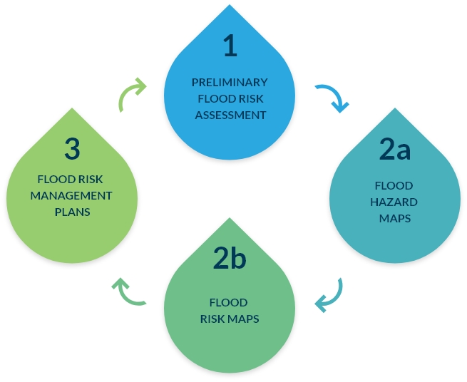
Fig. 1. Documents developed as part of the 6-year planning cycle
Definitions and types of floods
According to the Water Law Act, a flood is the temporary covering of an area by water that is not normally covered by water. In particular, the phenomenon is caused by water exceedance in natural watercourses, reservoirs, canals and from the sea, excluding the coverage by water exceedance in sewerage systems.
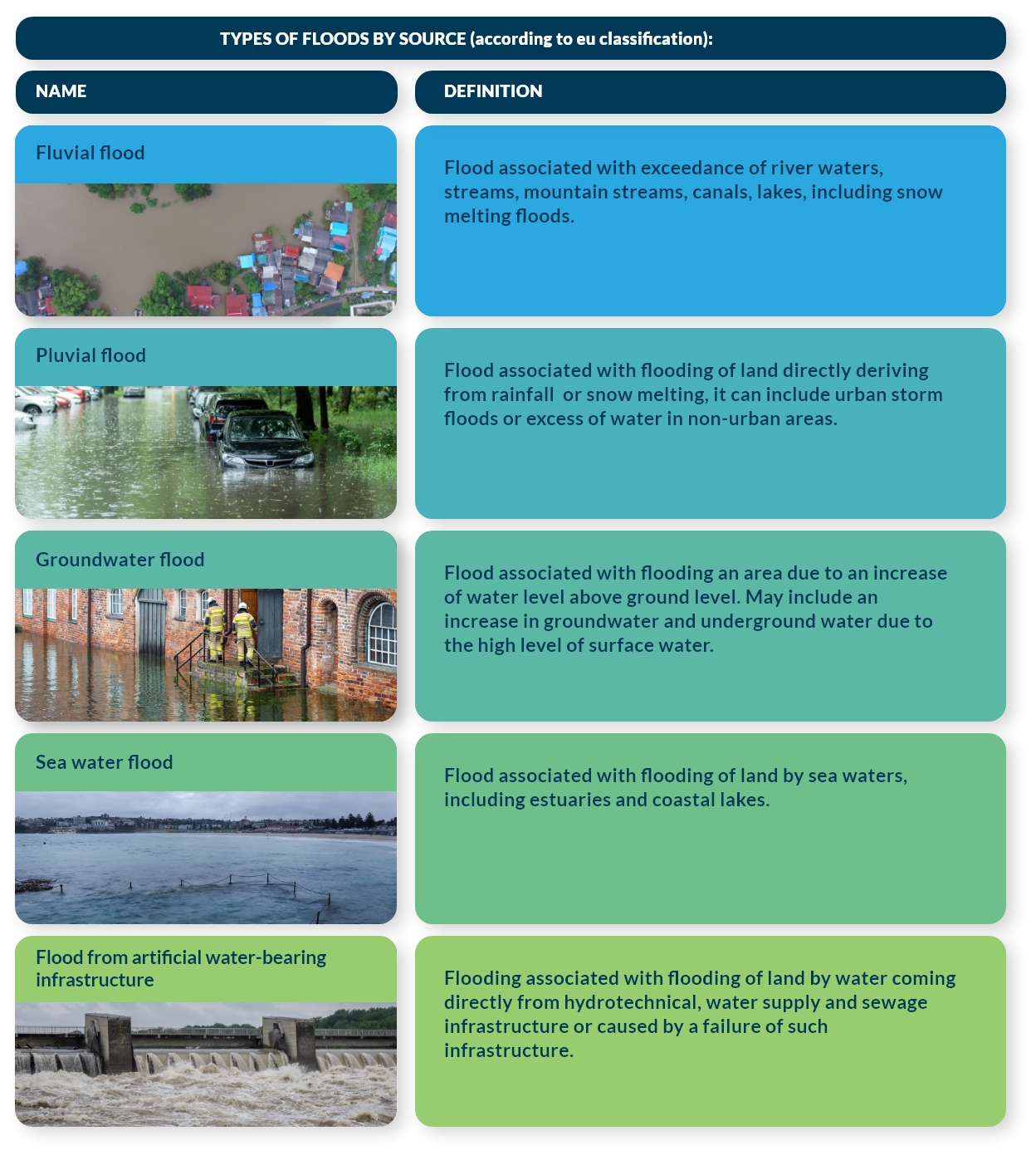
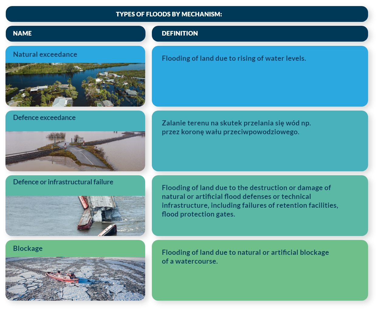
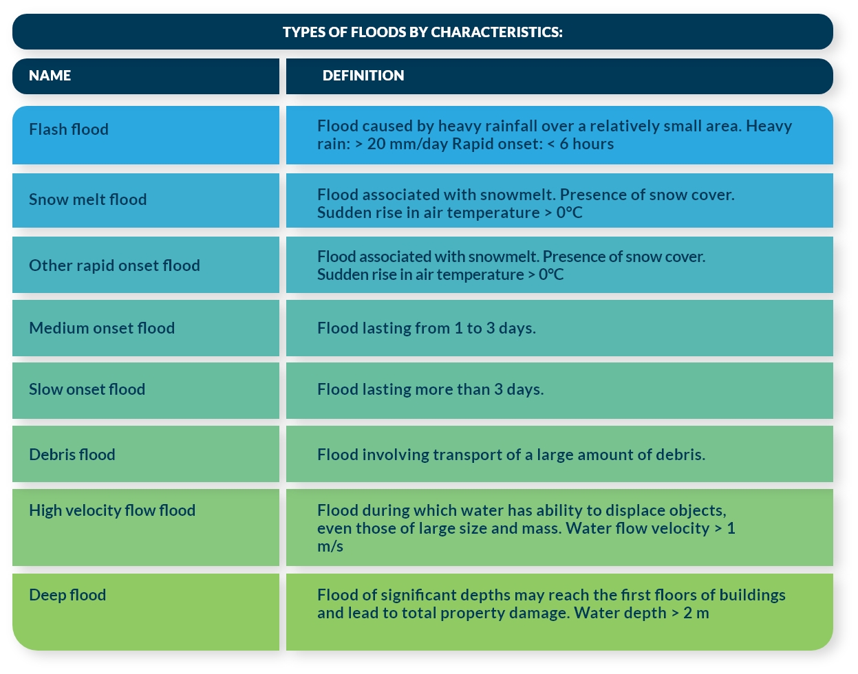
For the implementation of the Floods Directive in the EU, the uniform classification is used, distinguishing floods according to their source (origin), the mechanism of occurrence and their characteristics (features such as intensity of the phenomenon). (Fig. 2)
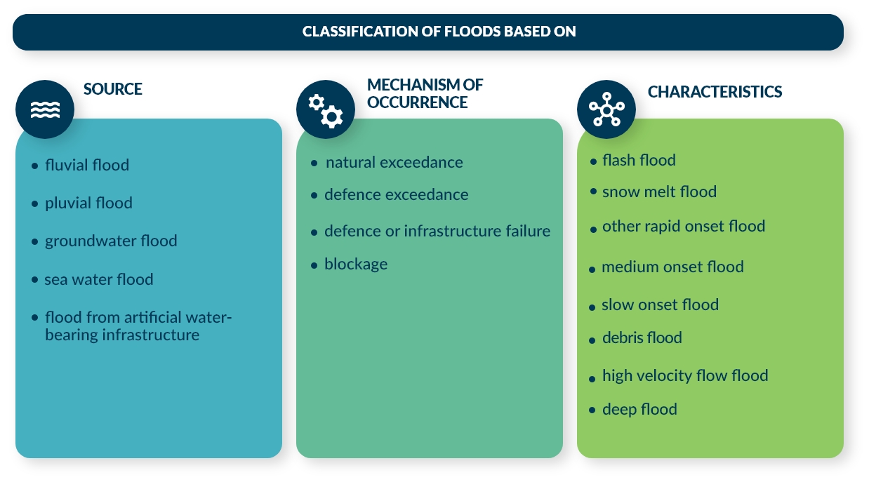
Fig. 2. Classification of floods used in the implementation of the Floods Directive
Definitions of the different types of floods are given below.
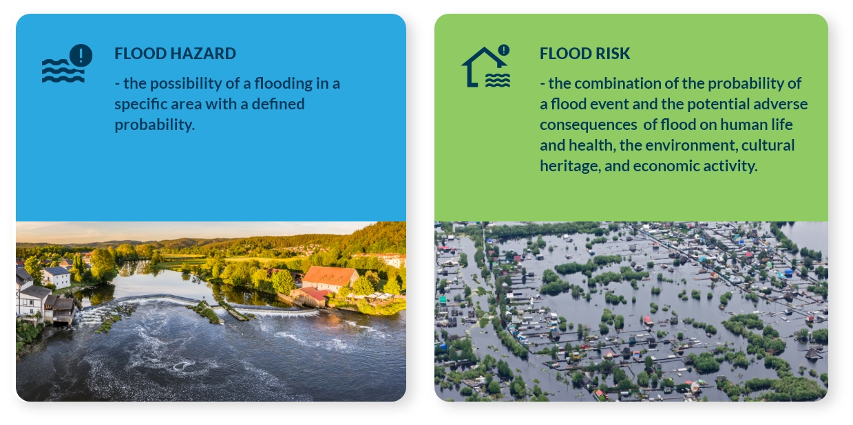
What is the difference between hazard and flood risk?
Scope of the preliminary flood risk assessment
The preliminary flood risk assessment shall include in particular:
1) Maps of the river basin districts, including the borders of river basins districts, the catchment area boundaries and the border of the coastal area, showing the topography of the area and its land use;
2) Description of historical floods, including:
- floods that occurred in the past and had significant adverse effects on human health, the environment, cultural heritage and economic activity, where the probability of a similar occurrence in the future remains high ( 4.2b of the Floods Directive);
- floods that occurred in the past and which did not have significant adverse effects at that time, but it can be predicted that a similar phenomenon in the future will have significant adverse effects, considering, for example, land use changes or climate change ( 4.2c of the Floods Directive);
3) The assessment of probable floods, i.e. floods that may occur in the future in a given area and have potential adverse effects on human life and health, the environment, cultural heritage and economic activity (Art. 4.2d of the Floods Directive).
The assessment of the potential adverse impacts of future floods taken into account:
- the topography,
- the location of watercourses and their general hydrological and geomorphological characteristics, including floodplains as natural retention areas,
- the effectiveness of existing water reservoirs and other flood control and regulatory structures,
- location of inhabited areas,
- location of areas where economic activity is carried out.
4) A forecast of long-term developments, in particular the impact of climate change on the occurrence of floods.
5) Identification of areas at risk of potential significant flood risk.
The preliminary flood risk assessment is conducted regarding all types of floods, and as a result of the analyses, significant flood types are identified for which areas of potential significant flood risk are determined.
The areas of potential significant flood risk designated in the PFRA do not form the basis for spatial planning. The purpose of the PFRA is not to determine the precise extent of flood risk areas, but to preliminarily identify them.